Our seasonal snowfall progress report.
It may seem hard to believe, but we’ve reached the final two months of the 2024–25 season at Alta Ski Area. Alta's spring semester is a great time to enjoy the mountains, with a 12-foot base and snow in the forecast, the skiing has been good and it's getting better by the day.
The stormy conclusion of 2024 kicked off a stretch of eight consecutive snowy Saturdays at Alta Ski Area, making up for a relatively slow start to the season. Weekly storms and a steady string of terrain openings have provided great skiing conditions. Alta Ski Patrol opened the Main Chute and High Shoulder of Mount Baldy in February and Alta Ski Area was open wall-to-wall—with the exception of Little Chute and Perla’s.
State of the Snowpack on March 1st
- October 2024: 17.5 inches of snow—66% of average (26.5”)
- November 2024: 66.5 inches of snow—94% of average (70.7”)
- December 2024: 71 inches of snow—78% of average (90.6”)
- January 2025: 83.5 inches of snow—87% of average (95.44”)
- February 2025: 109.5 inches of snow—121% of average (90.8")
As of March 1st, the Collins Study Plot recorded 348 inches of season-to-date snowfall—93.1% of Alta’s 44-year average October–February snowfall of 374 inches.
It's been a solid, if unspectacular, first five months of the season. A 93% average is a respectable A grade, but coming on the heels of the snowiest two-year stretch in Alta's history—which saw 1,531 inches of snow—you can't blame us for suffering a little bit of recency bias. In reality, the season's snowfall numbers are only 7% below an average Alta season. And an average season at Alta Ski Area still entails 548 inches of snowfall and plenty of powder days.
Despite four slightly below-average months to start the season, we managed to avoid any prolonged snowless stretches. Then, February delivered over nine feet of snow—our first month of above-average snowfall this season—bringing our season-to-date snowfall totals close to Alta's 44-year average.
With almost two full months ahead of us, we still have plenty of time to make up ground. March has historically been Alta’s snowiest month at 97.53 inches. Even April sees an average monthly snowfall of 76.39 inches. Average snowfall over the next two months (173.9 inches) would put Alta’s season-to-date snowfall at 522 inches—a couple storm cycles short of Alta’s 548-inch seasonal snowfall average.
How can we make up the difference? We don’t have to look back too far to find some hope.
- The 2023–24 season recorded 179 inches of snow between March 1st and April 30th.
- The 2022–23 season recorded 321 inches during the final two months of the record-breaking 903-inch season
- The 2018–19 season recorded 223 inches after March 1st.
As we've seen the past two seasons, the second half of the season can meet or exceed first half snowfall. Both seasons saw above-average snowfall in the first half of the season and carried that momentum through the end of April.
Our best comparison may be the 2009–10 season when the Collins Study Plot recorded 319.5 inches of snow by March 1st. The final two months delivered another 240.5 inches, lifting seasonal snowfall totals to 560 inches—102% of average.
 2024–25 season vs 2009–10 season | Alta.com
See how this season is stacking up >
Stay tuned to our Lift and Terrain Status page for the latest updates >
Fall & Winter Storm Recap
Relive some of the notable storm cycles from the first half of the season.
October 2024 | 17.5 Inches of Snow
Our first dusting of the season was on September 17th. Exactly one month later, we experienced top-to-bottom snowfall blanketing the fall colors of Alta.

October 17th: Eight inches of fresh snow | Photo: Rocko Menzyk
After a short break of summerlike weather, winter made its return at the end of October, delivering base-building snow and temperatures that allowed our snowmaking crew to fire up the snowguns.
In total, 17.5 inches of snow fell on the slopes of Alta Ski Area over the second half of October, 66% of our 44-year average (26.5"). October water clocked in at 2.13 inches, 70.5% of the 44-year average for October (3.02").
November 2024 | 66.5 inches of snow
Opening Day of our 87th season at Alta Ski Area was Friday, November 22nd. We opened the 2024–25 winter with a 23-inch base and 50-plus inches of season-to-date snowfall. It wasn’t the deepest or earliest opening in recent memory, but we were able to spin Wildcat and Collins lifts for expert skiers to explore Collins Gulch and the around-the-world corridor from the top of Collins over into Albion Basin.

November 22nd: Andrew Pollard finds soft turns on Opening Day | Photo: Rocko Menzyk
A quick-hitting storm dropped six inches of fresh snow at the close of Opening Weekend. The fresh snow made for some great skiing and provided additional coverage for expert skiers.

November 24th: Skiers enjoy six inches of new snow | Photo: Photo-John
Thanksgiving week brought remnants of an atmospheric river that delivered over 20 inches of new snow. Wednesday, November 27th served a powder buffet under blue skies and twinkling sun dogs. Alta Magic was in the air, welcoming skiers to the start of our 87th season.

November 27th: Ana Eyssimont comes up for air | Photo: Rocko Menzyk
The fresh snowfall and subsequent cold temperatures allowed our snowmaking crews and Alta Ski Patrol to expand our current lift and terrain offerings. Sugarloaf lift, East Baldy Traverse and Ballroom opened on Thanksgiving and Sunnyside opened the following day—allowing intermediate and beginner skiers to enjoy some November turns and plenty of leftover powder.
In total, November 2024 saw 66.5 inches of snow, 94% of the 44-year average (70.7”). November water totaled 5.03 inches, 81% of the 44-year average (6.18”).
December 2024 | 71 Inches of snow
We entered the first full month of the 2024–25 season under an extended stretch of high pressure. While we waited for the snow to fall, our snowmaking crews took advantage of the cold December nights and added some manmade depth to groomed runs. Our first flakes of the season fell on December 8th and 9th—a smaller storm that helped open the door to a series of storms heading into the middle of the month.

December 10th: An Alta local skis the first snowfall of December | Photo: Tyler Struss
The season had seen a few storms fall short of forecasted totals, so it was quite a surprise when the next storm delivered 11.5 inches of snow on a forecast calling for a trace to two inches. The new snow made for a great day of powder skiing and helped soften up turns around the mountain heading into the weekend.

December 13th: Ryan Mulkerin dives into a sleeper powder day | Photo: Lee Cohen
The next storm arrived from the southwest, the blowing winds and a few dense inches of snow acted as Mother Nature's grooming cats. Skiers flocked to the wind-buffed slopes of Alta as it began to look and feel like winter had made its return to Alta Ski Area.

December 16th: Piper Kunst enjoys a little Ballroom dancing | Photo: Rocko Menzyk
Following a week of mild weather and only a few dustings of snow, Santa stopped by Alta to ski a few laps and deliver some presents on Christmas Eve. We must have been on the Nice List this year because the flakes immediately started falling.

December 25th: Jon White skis powder in Westward Ho Ho Ho | Photo: Tyler Struss
Between Christmas Eve and New Year’s Eve, almost 50 inches of snow fell on the slopes of Alta. The new snow had our teams working around the clock to keep up with everything Mother Nature threw our way. The storm cycle fell on a sensitive early-season snowpack, requiring a little patience as we worked through avalanche mitigation during the holiday season.
As the ball dropped on New Year’s Eve, December 2024 registered 71 inches of snow, 78% of the 44-year average (90.6”). December water totaled 7.84 inches, 108% of the 44-year average (7.23").
January 2025 | 83.5 Inches of snow
The first storm of 2025 arrived in the early-morning hours of January 2nd, filling in the slopes of Alta with eight inches of graupel snow. It wasn't the typical mid-winter cold powder snow, but it helped fill in the post-holiday bumps and continued to build the base—it also made for some pretty great storm skiing.

Janaury 2nd: Jazz Vitale surfs some graupel | Photo: Rocko Menzyk
The next storm was a doozy. Following a day of south winds and five-star wind buff skiing, a strong winter storm made its way up Little Cottonwood Canyon in the pre-dawn hours of January 4th. The snow started falling around 5am at rates that reached five inches an hour. By noon, 17 inches of snow had fallen—creating plenty of congestion on Highway 210, a few delayed lift openings and some incredible powder skiing. Around 1pm, Highway 210 closed for mid-day avalanche mitigation, the results of which covered sections of the road in avalanche debris. With Little Cottonwood Canyon closed to vehicles and storm totals reaching 21 inches, Alta skiers enjoyed an afternoon of powder skiing at the Alta Country Club.

January 4th: Payton Lukes enjoyed her visit to the Alta Country Club | Photo: Photo-John
Interlodge went into effect and avalanche mitigation resumed at dawn on Sunday, January 5th. Ballroom, the Shoulder and Supreme Bowl opened, offering some great leftovers for those who missed Saturday's all-you-can-eat powder buffet. The new snow bumped our season-to-date snowfall up to 192 inches with a settled snow depth of 80 inches. A mid-week lull in the weather allowed Alta Ski Patrol to open the Backside wall-to-wall for the first time this season. What a way to start the new year!
For the third consecutive weekend, a storm took aim at Little Cottonwood Canyon. The snow started falling on Saturday morning, delivering six inches by the time lifts started spinning. But then the Northwest Flow turned on and the snowfall didn't stop.

January 11th: Saturdays in 2025 are for storm skiing | Photo: Photo-John
By Sunday morning, January 12th, almost two feet of snow had accumulated at the Collins Study Plot. Alta's teams went to work, grooming the main corridors, performing avalanche mitigation, clearing the snow from the parking lots, shoveling out the lifts and buildings and opening terrain in time for first chair.

January 12th: Annalise Bianco getting a faceful of Northwest flow | Photo: Photo-John
The terrain openings continued through the week and Devil Castle opened for the first time this season on Thursday, January 19th. The wall-to-wall opening of Devil's Castle under clear blue skies provided Alta skiers with two of their favorite activities: sidestepping and remarkable powder turns.

January 16th: Connor Pelletier finds some untracked snow under Devil's Castle | Photo: Rocko Menzyk
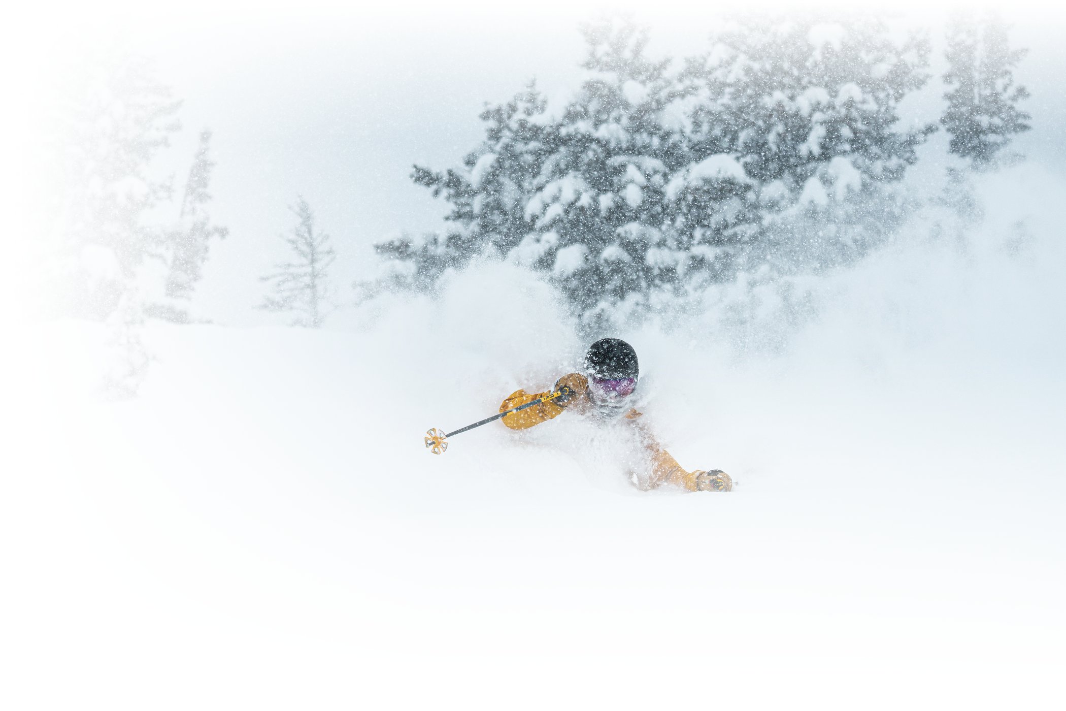
Heading into the Martin Luther King Jr. Weekend, the forecast called for some of the coldest temperatures of the New Year and a few inches of fresh snow. Stop us if this sounds familiar, but the storm outperformed the forecast and almost a foot of new snow fell throughout a powder-filled Saturday. The cold temperatures combined with the Northwest Flow to squeeze every flake out of the unsettled atmosphere, delivering 11 inches of cold smoke on the slopes of Alta.

January 18th: Ian Jones taking a cold smoke break in Westward Ho | Photo: Photo-John
Like clockwork at this point, the following week started cold, clear and windy. The groomers, wind buff and chalk made for a few days of great mid-week skiing before yielding to another weekend storm. For the fifth consecutive Saturday, an early-morning storm delivered fresh snow on the slopes of Alta. It wasn't the foot or two of snow we've seen the past four Saturdays, but the five inches of new snow made for fun storm skiing and another bluebird Sunday with rope drops and powder skiing.

January 26th: Another bluebird Sunday rope drop | Photo: Photo-John
A colder-than-usual January ended with a week of mild weather as another weekend storm made its way to Alta to kick off the new month.
in total, January 2025 registered 83.5 inches of snow, 88% of the 44-year average (95.4”). January water totaled 5.95 inches, 77% of the 44-year average (7.69").
February 2025 | 109.5 inches
February started with another snowy Saturday, pushing Alta’s season-to-date snowfall close to the 250-inch mark. Just as it was beginning to feel like Groundhog Day, the forecast hinted at a snowier pattern in February, including some long-awaited midweek storms.
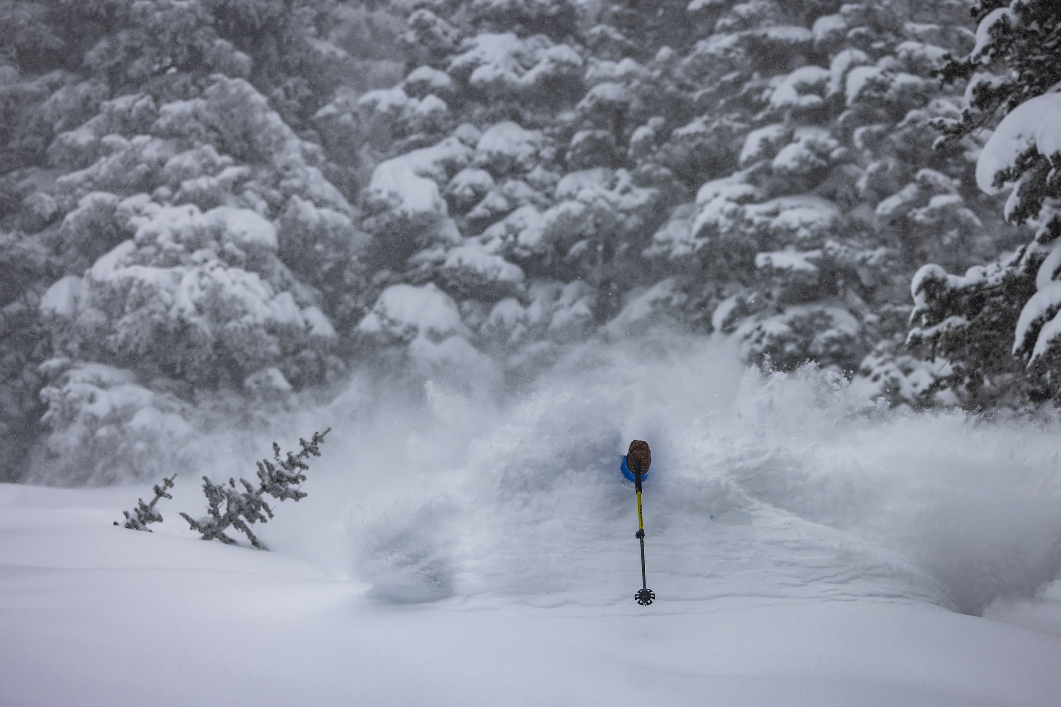
Following a midweek heatwave with plenty of wind, a storm on Friday, February 7th delivered 19 inches of new snow. The snow started as graupel, filling in the bumps on the firm surface from the midweek heatwave before transitioning to colder powder snow. It made for a wild day of storm skiing. Just as it appeared we may break our run of consecutive snowy Saturdays, a weak disturbance stirred up another six inches of fresh snow before last chair.

February 9th: Charlie Dehner is a fan of Super Blower Sunday | Photo: Photo-John
When the dust settled, over two feet of snow had fallen at Alta in time for Super Bowl Sunday. Our seventh consecutive snow-filled Saturday brought our season-to-date snowfall to 275 inches and a settled snow depth of almost eight feet.
The new snow allowed our teams to further expand our terrain as Mount Baldy's Main Chute and the High Shoulder opened for the first time this season on Monday, February 10th. The temperatures plummeted midweek before a long-duration winter storm took aim at Alta Ski Area, delivering a very snowy Presidents' Weekend. The snow started falling Thursday accompanied by strong winds and plenty of wind-buffed turns. Highway 210 closed overnight, Interlodge restrictions went into place and Alta Ski Area opened Valentine's Day morning with plenty of deep turns for powder lovers.

February 14th: Brooklyn Woods and Campbell Carter love powder | Photo: Rocko Menzyk
Once again, Highway 210 closed overnight for avalanche mitigation and Interlodge restrictions went into place through the Town of Alta as the snow kept falling. Early morning avalanche mitigation covered Highway 210 with debris, causing a delayed road opening. When Interlodge lifted on Saturday, February 15th, the Collins Study Plot recorded our first 100-plus-inch settled snow depth as Alta's season-to-date snowfall eclipsed the 300-inch mark. Storm totals reached 37 inches before the snow tapered off, making for one of the best powder days—and powder weekends—of the season.

February 16th: OpenSnow forecaster Evan Thayer verifies his forecast | Photo: Photo-John
Just as quickly as the 37-inch storm left town, the next wave made its way up Little Cottonwood Canyon. Between Presidents' Day and Wednesday, almost two feet of snow fell on the slopes of Alta during a period of unsettled weather. The off-and-on snowfall and a little wind made for incredible days of powder skiing as tracks seemed to fill back in between lift rides.

February 18th: Marcus Caston's return of the powder turn | Photo: Tyler Struss
Another stronger wave of snow dropped 10 inches of additional snow on Wednesday and Thursday. February snowfall totals reached triple digits as season-to-date snowfall approached 350 inches.
February 20th: Tommy Flitton storm skiing, yet again | Photo: Rocko Menzyk
Following eight days of new snow, the clouds lifted and Alta skiers were treated to a weekend filled with bluebird powder skiing. The run of eight consecutive snowy Saturdays came to an end, but Alta Ski Patrol utilized the break in the weather to open Devil's Castle and Mount Baldy on Saturday, followed by East Castle on Sunday.

February 23rd: Erin Spence skis bluebird powder on the first snowless Saturday in months
February drew to a close under a period of high pressure and spring-like conditions as Alta was open wall-to-wall.
A snowy February 2025 registered 109.5 inches of snow, 121% of the 44-year average (90.8”). January water totaled 11.45 inches, 162% of the 44-year average (7.06"). February 2025 was the third-wettest February in the 45-year history of the Collins Study Plot.
Add Your Comment